PENNSYLVANIA
G - P
GLEASON HILLTioga County
|

|
GLEN CAMPBELLIndiana County
|

|
GLEN SUMMITLuzerne County
|

|
GOOD SPRINGS
Schuylkill County
|

|
GOODALLTioga County
|

|
GOODWIN KNOBFayette County
|

|
GOULD'SWayne County
|

|
GOWeN CITY
Northumberland County
|
|
GRANDVIEWLuzerne County
|

|
GRASS(Y) FLATClearfield County
|

|
GREENLEE MOUNTAINHuntingdon County
|

|
GREENS KNOBHuntingdon County
|

|
GREENWOODHuntingdon County
|

|
GROVE MOUNTAINCameron County
|

|
HALL'S ROCKClinton County
|

|
HANLEYElk County
|

|
HARRISONTioga County
|
|
HARTLEYUnion County - Bald Eagle State Forest
|
|
HARVEYSLuzerne County
|

|
HAYS LOTJefferson County
|

|
HAYS MILLSSomerset County
|

|
HAZELTON
Luzerne County
|
|
HEAD OF BAILEY RUNCameron County
|
|
HEGE RIDGEPerry County
|

|
HEMINGWAYLycoming County
|

|
HIGH KNOBPike County
|

|
HIGH ROCKAdams County
|

|
HIGH TOPSnyder County
|

|
HIGHLAND FLINGCambria County
|

|
HOG BACKUnion County
|

|
HOLMES HURSTLycoming County
|

|
HOPEWELLBerks County
|

|
HOSTEINCambria County
|

|
HOUGH MOUNTAINCentre County
|
|
HUMBOLDTLuzerne County
|

|
HUNTLY HILLLycoming County
|
|
1914: A 50-foot wood tower constructed.

INDIAN SHANTYPotter County
|
|
1913: A tree observation post established.

JACKS MOUNTAIN (BUTLER KNOB)Huntingdon County - Rothrock State Forest
|

|
JACOBY MOUNTAINLycoming County
|
|
1913: A tree observation post established 28 feet above the ground.
1917: A tree observation post established 36 feet above ground.

JOHNSONMifflin County
|
|
1911: A tree observation post established 40 feet above the ground.

JONES MOUNTAINUnion County
|
|
An unimproved bald top observation post established prior to 1918.

KAHILLBradford County
|
|
KEATINGClinton County
|
|
KECKSBURGWestmoreland County
|
|
September 10, 1924: "The fire tower that is being built at Kecksburg will be completed within the week. A telephone line has been installed but it has not been connected yet. Within the next week some person will be chosen to have charge of the tower. With a man stationed at the tower a fire should be discovered within a few minutes after it starts and the manner in which the fire warden has the district organized, within 10 minutes a group of men should be at the scene of the fire. it was explained. A man will be stationed at the tower only during the fire season, which begins in October and closes December 1 and begins again in March. All persons who have subscribed to build the tower are invited to go to the tower and see what has been done with the money." (Connellsville Daily Courier)
March 13, 1936: "Work has been started on erection of a new fire tower at Ridge Chapel on top of Chestnut Ridge, one mile east of Kecksburg. Demolition of the Kecksburg tower will be started soon." (Connellsville Daily Courier)

KEEFER GAPFranklin County
|
|
1915: A tree observation post established 42 feet above ground.

KEFFERSSchuylkill County - Pennsylvania Bureau of Forestry
|

|
KELLOGG MOUNTAINBradford County
|

|
KINNEYTioga County
|
|
An unimproved bald top observation point established prior to 1918.

KINTON KNOBBedford County
|
|
*KINZUA (COAL HILL)
Warren County - Allegheny National Forest
|
|
*KNEVIL HILL
Lackawanna County
|
|
|
c.1918 - Chief Forest Fire Warden Report for 1918
|
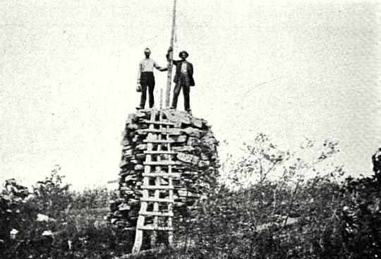
1890: A 15-foot tall solid rock tower constructed.
c.1913: The tower rebuilt.

KNOBBedford County
|
|
1912: A tree observation post established 40 feet above the ground.

KNOB MOUNTAINColumbia County
|
|
May 22, 1925: "An airplane is blamed by Fire Towerman Bruce Henrie for a blaze that swept over 700 acres of valuable timber land on Knob Mountain last night causing a loss of many thousands of dollars. He discovered the fire a few minutes after an airplane flying low, had passed over the wooded section. Henrie is confident something dropped from the plane to start the fire.
Several hundred men fought throughout the night to bring the fire under control and put it out this morning after several farm buildings had been threatened but saved." (Lebanon Daily News)

KNOPS
Clearfield County
|
|
KOOSER MOUNTAINSomerset County - Laurel Hill State Park
|

|
LAUREL MOUNTAINWestmoreland County
|
|
An unimproved bald top observation point established prior to 1918.

LAUREL RUNCentre County
|
|
1917: A tree observation post established 35 feet above the ground.

LAUREL RUNHuntingdon County
|
|
A 50-foot wood tower erected prior to 1918.

LEBOLycoming County
|
|
1912: A lookout post established 35 feet above the ground,

LEETioga County
|
|
LIGHTENERHuntingdon County
|

|
LINCOLN FARMElk County
|
|
1914: A tree observation post established 40 feet above the ground.

LITTLE BAERClinton County
|
|
1914: A 32-foot wood tower constructed.

LITTLE FLATCentre County - Logan State Forest
|
|
1917: A tree observation post 25 feet above the ground established.

LITTLE MOUNTAINFranklin County
|

|
LITTLE SHINNEYLuzerne County
|
|
LOLETAElk County
|
|
LONESOME PINEFranklin County
|

|
LONG MOUNTAINCumberland County
|

|
LONG RIDGELycoming County - Tiadaghton State Forest
|
|
LOST MOUNTAINCambria County
|
|
LOWER YODERCambria County
|

|
LYTLES KNOB (LOOP)Huntingdon County
|

|
MAPLE HILLLycoming County
|
|
MAPLE HILLTioga County
|

|
MARIENVILLEForest County
|

|
MARSHBURGMcKean County
|

|
MARTIN HILLBedford County - Buchanan State Forest
|

|
MAUCH CHUNKCarbon County
|

|
McDADEMcKean County
|

|
MEHOOPANYWyoming County
|

|
MIDDLESWARTHSnyder County
|

|
MT BEACON (HEDGEHOG ROAD)McKean County
|
|
April 16, 1931: "There are now only two fire towers in McKean County, one on Bush Hill, east of Smethport and one just north of Kane. The towers at Rock City, N.Y., Kinzua in Warren County and in the northeast corner of Elk County, southwest of Betula, also assist in furnishing protection to McKean County, not properly protected by a fire tower is the northwestern portion and it has just been arranged to erect an eighty foot fire tower on Mt. Beacon, the highest point in that section of the county, with an air-way beacon upon which it is the plan of the Harri Emery Airport Association to place a beacon at some future date. This tower is being erected and paid for entirely by the McKean County Protective Fire Association and will be known by a name to be selected by the school children of the city of Bradford, the townships of Croydon, Foster, Bradford, Otto, Keating, Lafayette and Hamilton on the plan hereinafter outlined.
These plans in the making for the construction of a new and better road from the Bennett Brook road to the site of this tower in order that they may get a view of McKean County from the top of the structure." (McKean County Miner)
April 23, 1931: "A third fire tower will be erected in McKean county according to reports, in the Northwestern portion of the county, the only section which is not properly protected from forest fires. It will be an eighty foot tower and will be erected on Mt. Beacon, the highest point in that section of the county, with an airway beacon top, on which it is planned by the Harri Emery Airport Association to place a beacon at some future date. This tower is being erected and paid for entirely by the McKean Protective Fire Association and will be known by a name to be selected by the school children of the city of Bradford, the townships of Croydon, Foster, Bradford, Otto, Keating, Lafayette and Hamilton on the plan as hereinafter outlined.
There are now only two fire towers in McKean county, one on Bush Hill, east of Smethport, and one just north of Kane.
A new and better road will be constructed to the site of the tower." (McKean County Democrat)
October 18, 1935: "Mt Beacon fire tower observation point for the northern fire district of McKean county, located less than two miles west of Bradford, opened for the fall season this morning.
Although the forest is pronounced unusually dry and opening of the tower is at least two weeks later than many in previous years, Mr. Coleman reported there have been no fires discovered in the woods yet.
Telephone service will be installed in the tower today under the sponsorship of the McKean County Protective Fire Association. Its number is Bradford 2-1238." (The Olean Times-Herald)

MOUNT DAVISSomerset County - Forbes State Forest
|
|
MOUNT DUNLAPFranklin County
|

|
MOUNT MINSI
Monroe County
|
|
MOUNT PLEASANTSchuykill County - Weiser State Forest
|

|
MUZETTEForest County
|
|
NEGRO MOUNTAINSomerset County - Forbes State Forest
|

|
NORTH MOUNTAINSullivan County - Wyoming State Forest
|

|
OAK KNOBFranklin County
|

|
OLD TOWNClearfield County
|

|
OWLS NESTElk County
|
|
PADDY MOUNTAINCentre County
|

|
PENN VIEWIndiana County
|

|
PENNSYLVANIA STATE CAPITOL BUILDING
Dauphin County
|
|
|
no date - Press photo, Ron Kemnow Collection
|
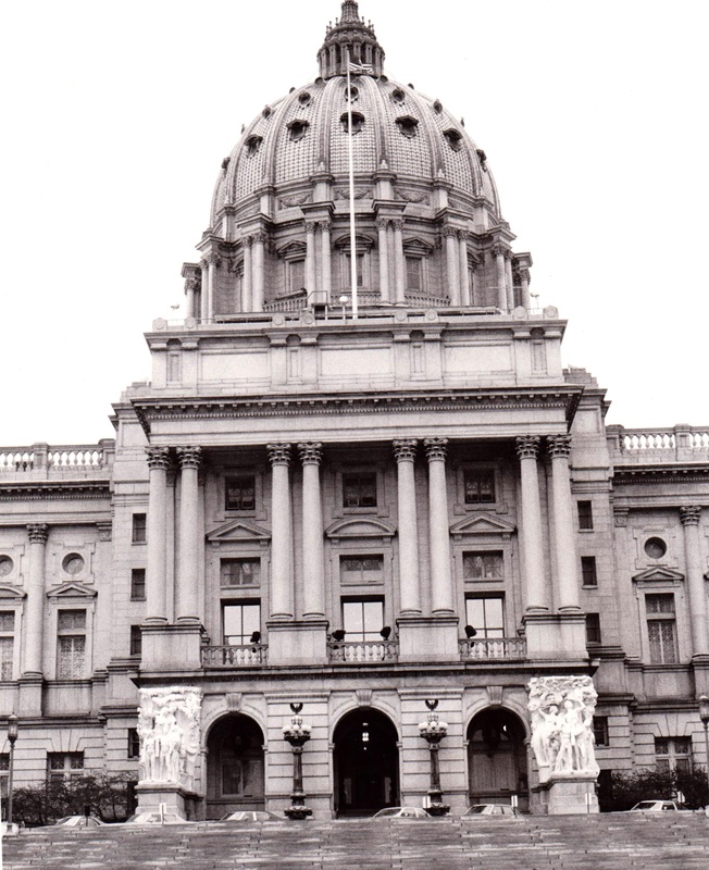
April 13, 1921: "The state capital dome Tuesday was made a fire observation by the department of forestry and Thomas F. Burns was stationed there by Commissioner Pinchot to note appearance of forest fires in the mountains about Harrisburg. The dome rises more than 270 feet above the level of the Susquehanna and mountains in Dauphin, Cumberland, Perry, York and Lebanon counties can be discerned with a strong glass. The department also has established on Peters mountains, Dauphin county, where several fire have occurred and this patrol will be able to see mountains in the Susquehanna and Juniata valleys." (Lock Haven Express)
February 16, 1922: "State capitol building may serve as a fire tower, it was stated this morning. Hope was held out that when the state forestry authorities post observers on the dome balcony the state police project for the installation of a telephone service from there may be realized." (The Morning Herald)

*PENOBSCOT (MOUNTAIN TOP)
Luzerne County
|

|
PIMPLE HILLMonroe County
|
|
PINDLETONCambria County - Gallitzin State Forest
|

|
PINE HILLPotter County
|

|
PINE MOUNTAIN
Franklin County
|

|
PITTSTON
Luzerne County
|
|
PLUMERVenango County
|
|
May 14, 1949: "Seventy workmen of the Pennsylvania Railroad including crews from Tionesta, worked Thursday afternoon and night to extinguish a series of forest fires at Walnut Bend, Henry's Bend, President and the north side of Rockmere. A locomotive was blamed for starting the fires, which were observed by the State fire observer at the Plumer tower. The observer phoned the Oil City P.R.R. offices for help." (The Titusville Herald)

POCONO MOUNTAIN (KNOB) (LAKE)Monroe County
|
|
1915: "During the month of May, patrolman Shaller, stationed at Mount Pocono, opened a subscription for the purpose of building a look-out to increase the range of vision over the outlying regions. The boarding house proprietors readily subscribed the amount necessary for its erection. While serving as a fire observation tower for the patrolman, at the same time guests at the various inns will see in it an added attraction in the way of affording a view of the surrounding country.
I made plans and specifications for its erection, and helped to erect it. At this time, I desire to commend the aggressiveness and industry of our patrolman at Mount Pocono, through whose activity the proposed look-out became an actuality. A small deficit was met by the Pocono Protective Fire Association, and the look-out became its property on completion." (Report of the Chief Forest Fire Warden for 1915)
1915: A 25-foot wood tower constructed.
March 12, 1950: "Work on the Pocono Mountain Auto Speedway will start early in April, as soon as the weather permits, George Perluke, speedway promoter, said last night.
The speedway will be constructed on Route 115 at the foot of the Pocono Mountain Fire Tower in the scrub oak section of Effort Mountain, which is about 28 miles from Wilkes-Barre and five miles south of Blakeslee Corners." (Wilkes Barre Sunday Independent)

POHOPOCOMonroe County - Pennsylvania Bureau of Forestry - Delaware State Forest
|

|
PONDFIELDFayette County
|

|
PONDFIELD 2
PORT CLINTONBerks County
|

|
PROSPECT HILLMcKean County
|

|
*PUMP STATION
Lycoming County
|

|
PURDUE
Centre County
|
|
