WEST VIRGINIA
*BACKBONE MOUNTAIN (OLSON)
Tucker County - Monongahela National Forest
|

|
*BALD KNOB
Pocahontas County - West Virginia Division of Natural Resources
|

|
BARTON KNOBRandolph County - West Virginia Division of Forestry
|

|
*BEARDEN KNOB
Tucker County - Monongahela National Forest
|

|
BEAVER LICK MTN (WHITE RK)
Pocahontas County - National Forest
|

|
BEE MOUNTAINKanawha County - West Virginia Div. of Forestry
|

|
*BELL KNOBGrant County - Monongahela National Forest
|

|
BERWINDMcDowell County - West Virginia Division of Forestry
|

|
*BICKLE KNOB
Randolph County - Monongahela National Forest
|

|
BIG MOUNTAINWebster County - West Virginia Div. of Forestry
|

|
*BIG RIDGE
Hardy County - West Virginia Division of Natural Resources
|

|
BLACK MOUNTAINPocahontas County - West Virginia Div. of Forestry
|

|
BLAIR MOUNTAINLogan County - West Virginia Division of Forestry
|

|
*BRIERY KNOB
Pocahontas County - West Virginia Division of Forestry
|

|
BRUSHY MOUNTAINGreenbrier/Monroe Counties - West Virginia Div. of Forestry
|

|
BUCK KNOBLincoln County - West Virginia Div. of Forestry
|

|
BUFFALO MOUNTAINMingo County - West Virginia Division of Forestry
|

|
BURNING ROCKWyoming County - West Virginia Div. of Forestry
|

|
CABELLCabell County - West Virginia Division of Forestry
|

|
CABIN HILLLogan County - West Virginia Conservation Commission
|

|
CADDELL MOUNTAINPreston County - West Virginia Div. of Forestry
|

|
*CANAAN MOUNTAIN
Tucker County - Monongahela National Forest
|

|
|
1927 - National Archives (OPA)
|
1927 - National Archives (OPA)
|
|
1933 - National Archives (OPA)
|
1937 - National Archives (OPA)
|

CARLIN HILLWetzel County - West Virginia Division of Forestry
|

|
CHEAT VIEWMonongalia County - State
|

|
CHERRY POND MOUNTAINRaleigh County
|

|
CHERTLAND MOUNTAINMineral County
|
|
COALWOODMcDowell County - Private
|

|
COTTLE KNOBNicholas County - West Virginia Division of Forestry
|
|
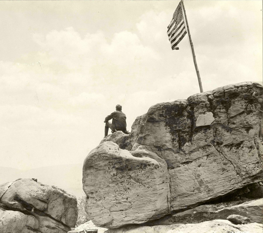
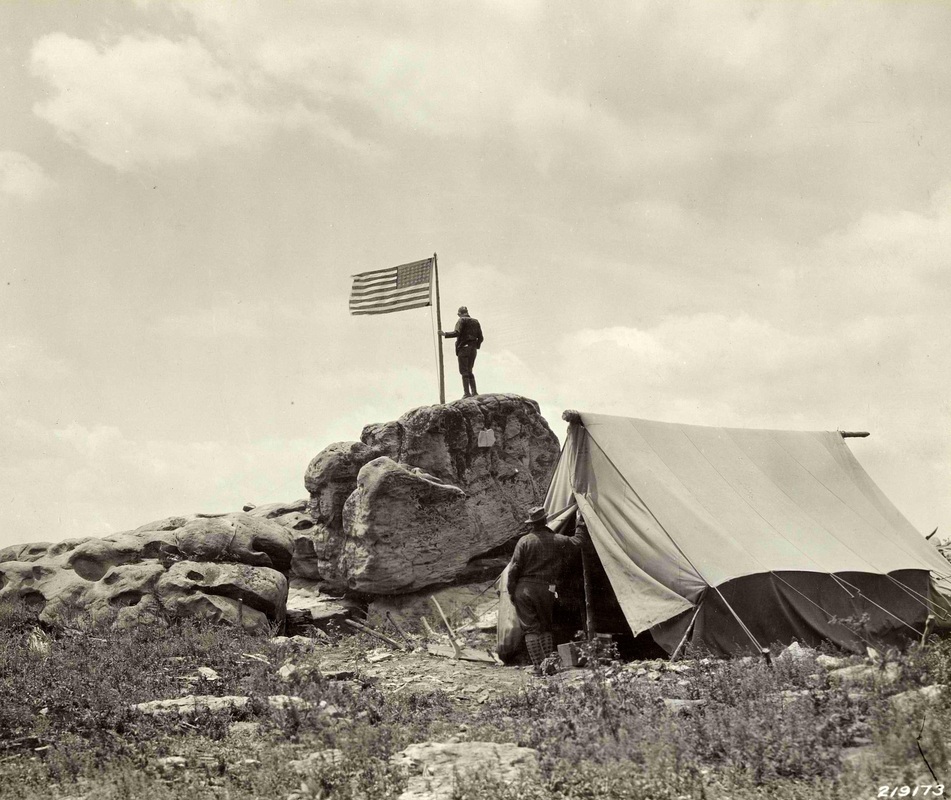
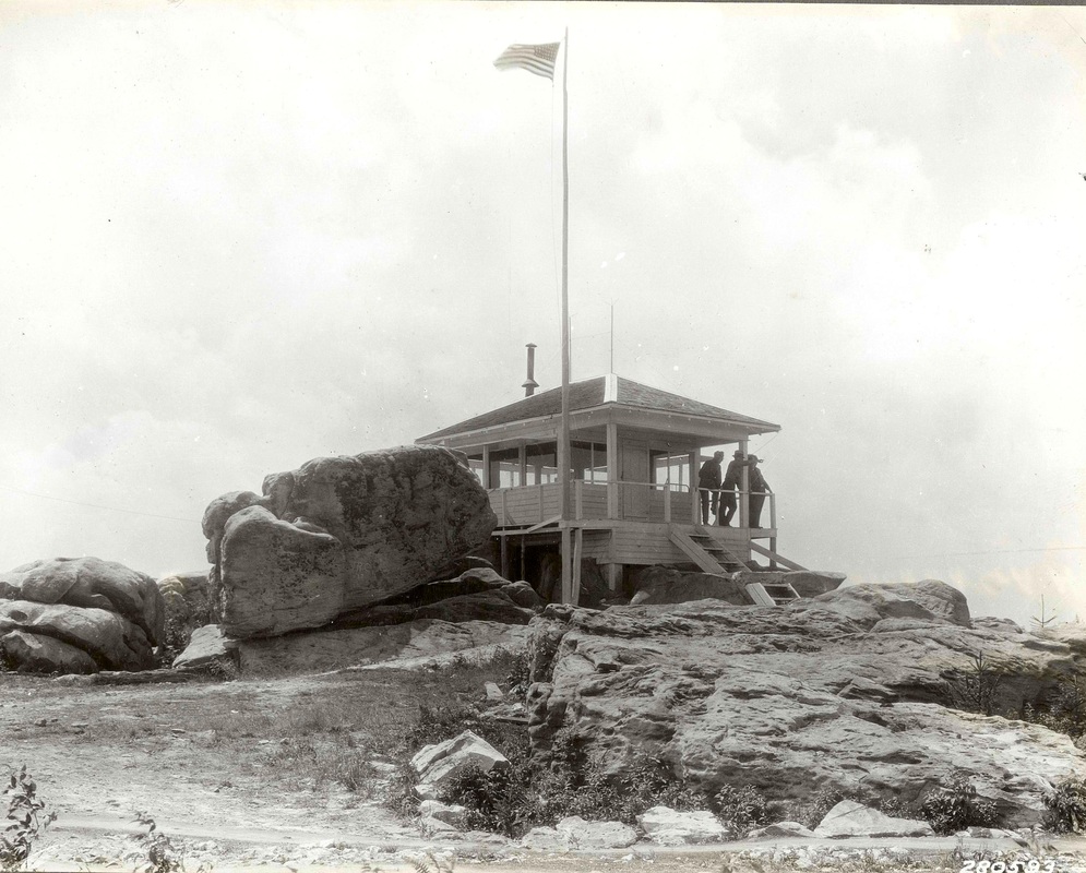
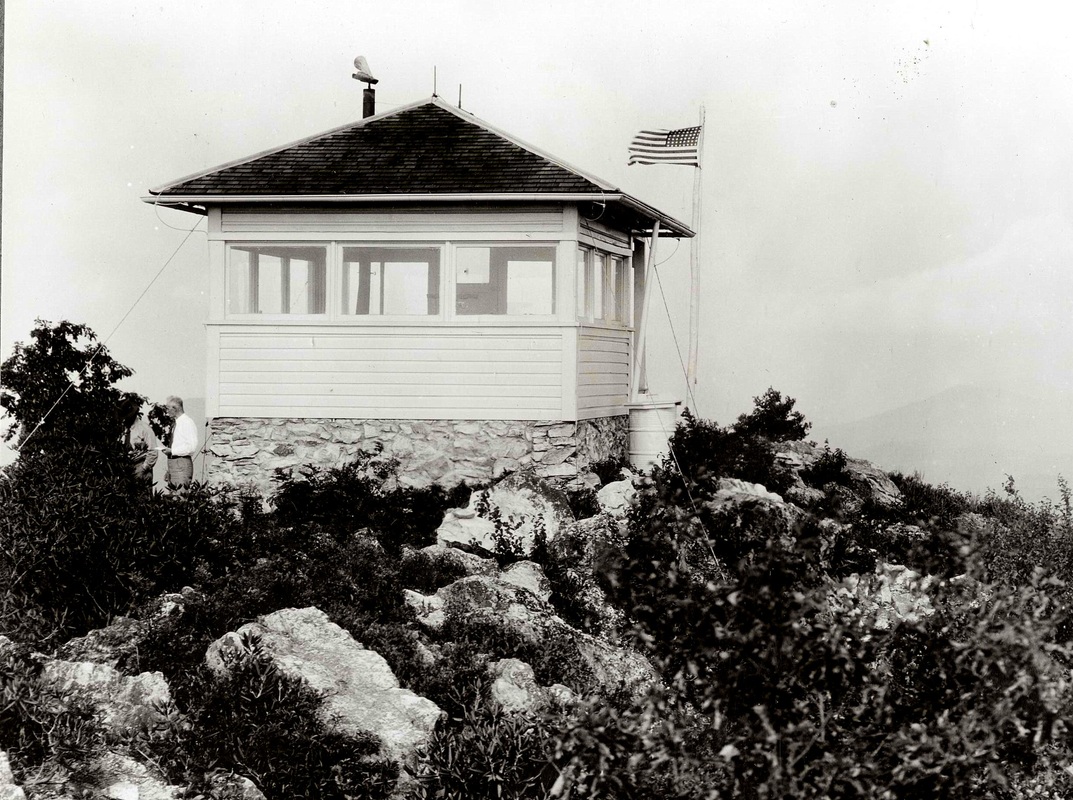
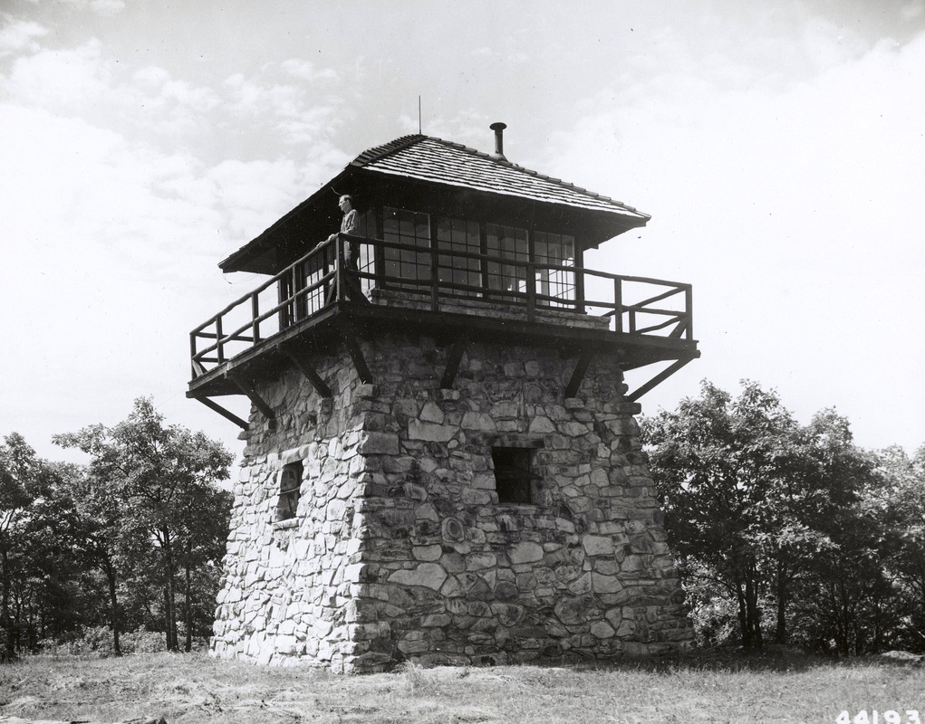
*DOLLY SODS (PLAINS)
Grant/Tucker Counties - Monongahela National Forest
|

|
ELK KNOBBoone County - West Virginia Conservation Commission
|

|
ELK HORN ROCKGrant/Hardy County - West Virginia Div. of Forestry
|

|

*FATEWOOD (Same as Gatewood ???)
Monongahela National Forest
|
1933 - National Archives (OPA)
|


GARTIN KNOBLincoln County - West Virginia Division of Forestry
|
|
GATEWOODRandolph County - Monongahela National Forest
|

|
GAUDINEER KNOBPocahontas County - Monongahela National Forest
|

|
GAULEY MOUNTAINFayette County - West Virginia Div. of Forestry
|

|
GRASSY KNOBGreenbrier County - West Virginia Division of Forestry
|
|
HALF MOON MOUNTAINHardy County - Shenandoah National Forest
|

|
HANGING ROCK (PETERS MOUNTAIN)Monroe County - Jefferson National Forest
|

|

*HIGH POINT (KNOB)
Hampshire/Frederick (Va.) Counties - George Washington National Forest
Situated on the state line between West Virginia and Virginia.
|
1946 - National Archives (OPA)
|

HOLLY RIVER STATE PARK
Webster County - West Virginia Conservation Commission

HOPKINS MOUNTAINGreenbrier County - Monongahela National Forest
|

|
HUFF KNOBRaleigh County - West Virginia Div. of Forestry
|

|
IVY KNOBRaleigh/Wyoming Counties - West Virginia Div. of Forestry
|

|

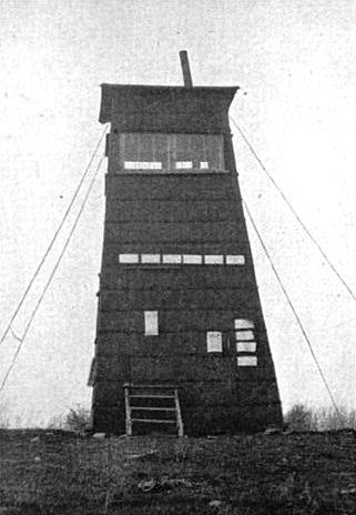
JACKSON KNOB
Fayette County
October 10, 1926: "The Jackson Knob tower connects with the mine telephone system at Whitaker which is served from the East Bank central office." (Telephone service) (Charleston Gazette)

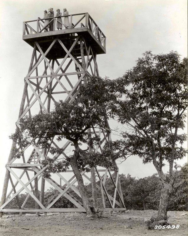
*JOB KNOB
Greenbrier County - State
|
c.1915 - 4th Biennial Report of the FG&F Warden
|
1913-14: "Honorable H.E. Williams donated all of the lumber and delivered same on the ground for the Job Knob Station." (Biennial Report - Forest, Game & Fish Warden - West Virginia - 1913-14)
1916: "This station is located in Williamsburg District, Greenbrier County, nineteen miles from Richwood, and is under the supervision of David Frame. The station may be reached by carriage or on horseback from Richwood. The elevation is 4,388 feet and commands a view of approximately 800 square miles. The watchman, James H. McMillion, lives nine miles from the station, and stays at the station each night. He receives his mail at Trout, West Virginia, once a week, and telegrams can be delivered to the station in twenty minutes from Renick. West Virginia." (4th Biennial Report of the Forest, Game and Fish Warden)

JOHNSON KNOBKanawha County - West Virginia Div. of Forestry
|
|
April 26, 1929: The Southern West Virginia Fire Protective association appropriated $1,500 for the construction of a 73-foot steel forest observation tower at Johnson Knob, Kanawha county. (Charleston Daily Mail)
Removed

KEENEY KNOBSummers County - West Virginia Div. of Forestry
|

|
LAMBERT KNOBWyoming County - West Virginia Div. of Forestry
|

|
LAUREL HILLBarbour/Randolph Counties - West Virginia Division of Forestry
|

|
LIBERTYPutnam County - West Virginia Dept. of Natural Resources
|
|
LICK KNOBFayette/Raleigh County - West Virginia Div. of Forestry
|

|
LITTLE MOUNTAIN
Pocahontas County - National Forest
LONE STARNicholas County - West Virginia Div. of Forestry
|

|

LOUDOUN HEIGHTS
.
Removed

MANN MOUNTAINFayette County - West Virginia Div. of Forestry
|

|

McGOWAN
Tucker County - State
May 20, 1913: $142.50 was spent on trail and telephone line construction. (West Virginia - Forest, Game & Fish Warden Biennial Report 1913-14)
1916: "This station is located in Black Fork District of Tucker County, three miles from Hambleton, and is under the supervision of F.M. Glenn. The station may be reached on foot from Hambleton. The elevation is 3,354 feet and commands a view of approximately six hundred square miles. The watchman, Clyde Westfall, lives at Hambleton and only stays at the station at night when there is very dry weather. He receives his mail each day at Hambleton, and telegrams can be delivered to him from the same point by phone in ten minutes.
Two and three-fourths miles of phone line have been built. This is known as the "McGowan Line,' and connects with the Mutual Lines at Hendricks. The line is partly built on poles and partly on trees and is in fair condition." (4th Biennial Report of the Forest, Game and Fish Warden)

MICHAEL MOUNTAINPocahontas County - West Virginia Conservation Commission
|

|

MIKES KNOBGreenbrier County - Monongahela National Forest
|

|

MINGO (HORSEPEN MOUNTAIN)Mingo County - West Virginia Division of Forestry
|

|

MOUNTAIN VIEW
Pocahontas County - State
1914: A lookout was established on this point.
1916: "This station is located in Edra District, Pocahontas County, four and one-half miles from Marlinton, and is under the supervision of F.M. Glenn. The station may be reached on foot or horseback from Marlinton. The elevation is 3,198 feet and commands a view of approximately 450 square miles. The watchman, Warwick Ratliff, lives within one-half miles of the station, and has phone service to his house, so only stays at the station at night during very dry weather. He receives his mail daily from Marlinton, from which point telegrams can be delivered to him within ten minutes by phone.
Three-fourths of a mile of phone line has been built to this station, this being known as the 'Birds Run Line,' and connecting with the Mutual Lines of the Mountain View Orchard. The line is built on poles and is in fair condition." (4th Biennial Report of the Forest, Game and Fish Warden)

MOZARK MOUNTAINTucker County - Monongahela National Forest
|

|

MT DESERTKanawha County - West Virginia Div. of Forestry
|

|

NATHANIEL MOUNTAINHampshire County - West Virginia Division of Forestry
|

|

NIGES CLIFFPendleton County - West Virginia Conservation Commission
|

|

NORTH MOUNTAINBerkeley County - West Virginia Division of Forestry
|

|

*NORTH FORK MOUNTAIN
Pendleton County - Monongahela National Forest
|
1935 - National Archives (OPA)
|
1935 - National Archives (OPA)
|
Removed

OLGAMcDowell County - Olga Coal Company
|

|

OLGA #2
McDowell County

OLGA #3
McDowell County

PANTHER STATE FORESTMcDowell County - West Virginia Div. of Forestry
|

|

PARTING SPRINGS
Randolph County - West Virginia Division of Forestry
October 10, 1926: "The Parting Springs tower is served by a telephone connected with the Ranwood Store at Pickens where messages may be relayed over the lines of the Chesapeake and Potomac Telephone company." (Charleston Gazette)

PICKERING KNOB
Mingo County - West Virginia Division of Forestry
Removed

PIGEON ROOSTGrant County - West Virginia Division of Forestry
|

|

PIKE KNOBPendleton County - National Forest
|

|

PILOT KNOBMercer County - West Virginia Division of Forestry
|

|
PINE KNOB
McDowell County
|
|
PINEY KNOBBoone County - West Virginia Division of Forestry
|

|
PINNACLE KNOBMineral County - West Virginia Division of Forestry
|
|
POINT MOUNTAINWebster County - West Virginia Division of Forestry
|

|

POND RIDGE (WIDEN)
Clay County - West Virginia Division of Forestry

POPLAR RIDGE
Braxton County - West Virginia Conservation Commission

RED OAKWebster County - Monogahela National Forest
|

|

RED SPRUCEPocahontas County - Monongahela National Forest
|

|

RICH KNOBGreenbrier County - West Virginia Div. of Forestry
|

|

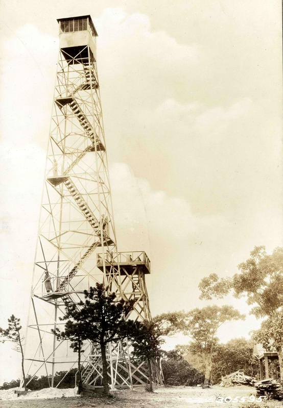
RICH MOUNTAIN
Randolph County - West Virginia Division of Forestry
July 9, 1925: "The Rich Mountain tower in Randolph county has an average observation range of 20 miles and in some directions forests for 30 miles can be observed from it." (Charleston Gazette)
October 10, 1926: "The Rich Mountain tower in Randolph county is connected with the central office of Beverly>" (Telephone service) (Charleston Gazette)
1999: The lookout tower was purchased by the Snowshoe Mountain Ski Resort, dismantled and re-erected at the resort.

ROUND KNOBRaleigh County - West Virginia Div. of Forestry
|

|
SAND SPRINGSPreston County - West Virginia Division of Forestry
|
|
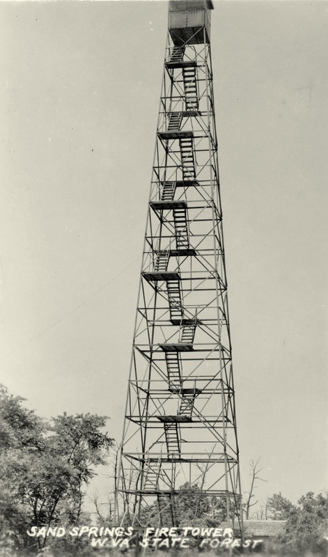 postcard, pm 1942 - Ron Kemnow Collection
|
Removed

SHARP'S KNOBPocahontas County - Monongahela National Forest
|

|

SHAWNEE MOUNTAINMcDowell County - West Virginia Div. of Forestry
|

|

SIDELING HILL
Morgan County - West Virginia Division of Forestry
1929: A tower was erected.

SIGNAL KNOB
Pocahontas County - State
|
c.1915 - 4th Biennial Report FG&F Warden
|
1913-14: "Wildell Lumber Company furnished lumber and assisted in construction of Signal Knob Station." (Biennial Report - Forest, Game & Fish Warden - West Virginia - 1913-14)
1916: "This station is located in Green Bank District, Pocahontas County, two miles from Wildell, and is under supervision of F.M. Glenn. The station may be reached on foot from Wildell. The elevation is 4,200 feet, and commands a view of approximately 900 square miles. The watchman, Paul Jones, lives two miles from the station and goes home each night except in very dry weather. He receives his mail daily at Wildell, from which point telegrams can be delivered to him by phone in ten minutes.
Two miles of phone line, known as the 'Signal Knob Line," has been built to the station, and connects with the Association line at Wildell. This line is built on trees and is in fair condition." (4th Biennial Report of the Forest, Game and Fish Warden)
October 10, 1926: "The tower at Signal Knob near Wildell in Greenbrier County is connected by National Forest telephone circuits." (Charleston Gazette)

SLEEPY CREEK MOUNTAINBerkeley County - West Virginia Division of Forestry
|

|

SMOKE CAMP KNOBPocahontas County - Monogahela National Forest
|

|

SNAGGY MOUNTAINPreston County - Maryland Department of Natural Resources
|

|

SNOWSHOEPocahontas County - Private
|

|

SPRING MOUNTAINLogan County - West Virginia Division of Forestry
|

|

SPRUCE KNOBPendleton County - State
|

|

STOP KNOBFayette County - West Virginia Conservation Commission
|

|

SUGAR GROVE KNOBNicholas County - West Virginia Division of Forestry
|

|

TAMS MOUNTAINRaleigh County - West Virginia Div. of Forestry
|

|

THORNY MOUNTAINPocahontas County - West Virginia Division of Forestry - Seneca State Forest
|

|

TICK RIDGEWayne County - West Virginia Division of Forestry
|

|

TIP TOPPreston County - State
|

|

TURKEY MOUNTAIN (KNOB)Webster County - State
|

|

WEISS KNOBTucker County - State
|

|

WHITE OAK KNOBBoone County - West Virginia Division of Forestry
|

|

WILLIAMS HILLBoone County - West Virginia Division of Forestry
|

|

WRISTON KNOB (BACON KNOB)Raleigh County - West Virginia Div. of Forestry
|

|
MISC. NOTES - WEST VIRGINIA |

|
